| Bottomland Farm ~ MAP |
| 1. Abstract No. 5392 |
| Property Description |
| A tract in the southeast part of the northwest quarter of section 19, in township 53, of range 20, containing 59 acres, more or less, and particularly described as follows: |
| | Beginning in the southeast corner of the northwest quarter of said section 19, thence north 14 minutes east 1366 feet to a stake, thence west 10 minutes, south 1900 feet to a stake, thence south 55 minutes west, 1357 feet to a stake, then east 10 minutes north to the point of beginning (the "Property"). |
| Summary of Title |
| 1858 - | Part of Property (southeast quarter of northwest quarter) conveyed as part of larger 290.175 acre tract consisting of the "southeast quarter of the southeast quarter and the west half of the southeast quarter and the northeast quarter of the southwest quarter and the east half of the northwest quarter and the southwest quarter of the northeast quarter of section 19, in township 53 (south of Missouri River) of range 20, in the District of lands formerly subject to sale at Fayette, now Boonville, Missouri" ("Mayer Tract") by U.S. Government to Lipmann Mayer (004). |
| 1891 - | Mayer Tract conveyed to A.H.W. Sullivan by quitclaim deeds from Louis and Yetta Stix for $1200 (013) and from Caroline Swartz, Nathan Stix, and Ricka (or Richa) Stix for $1200 (014). |
| 1846 - | Remainder of Property (south half of lot no. 2 of northwest quarter) conveyed as all or part of 53.17 acre tract ("Tempest Tract") by U.S. Government to Tempest Tucker Sullivan (016 and 052). |
| 1854 - | Tempest Tract conveyed by warranty deed from Tempest and Priscilla Sullivan to James Sullivan (017). |
| 1859 - | Tempest Tract conveyed by warranty deed from James and Rosanna Sullivan to Absolum Chorn (018). |
| 1866 - | Absolum and Sarah Chorn gave deed of trust on certain of their property, including Tempest Tract, to Samuel Sullivan, acting as Trustee for the estate of George Rider (019). |
| 1875 - | Tempest Tract conveyed by warranty deed from Absolum and Sarah Chorn to James A. Dobbins (020). |
| 1886 - | The estate of James A. Dobyns was probated by the Public Administrator, James Wingfield, upon application of decedent's son, Charles A. Dobyn, and the abstractor writes that no papers were on file in the probate court for this estate (021). Later, in 1901, Wingfield is discharged in an order reflecting that there is no property belonging to the estate in his hands (022). |
| 1899 - | Tempest Tract conveyed to Amos H.W. Sullivan by warranty deeds from David and Eliza Dobbins for $250 (023) and from Charles and Jennie Dobbins, Samuel and Mary Hisle, John and Lulu Jennings, James and Ida Hisle, J. Watter and Sophia Hawkins, and John and Carrie Gibbons for $1367.23 (024). |
| 1899 - | "Undivided 5/7 interest in the Southwest quarter of the Northwest quarter of Section 19, in Township 53, in Range 20, containing 53.80 acres, in Saline County, Missouri" (unclear whether this overlaps with or is separate from Tempest Tract and the abstract doesn't say anything about the other 2/7 interest) conveyed to Amos H.W. Sullivan by warranty deed from Mary and Samuel Hisle, Sophia and J.W. Hawkins, Ida and James Hisle, Lulu and J.W. Jennings, Carrie and J.C. Gibbons, heirs of Ellen Dobbins, dec'd, and Charles and Jennie Dobbins for $1125 (026). |
| 1936 - | A.H.W. Sullivan died intestate in 1935, leaving 18 heirs with undivided interests in substantial real estate. The heirs agreed that each would surrender his or her fractional share of the whole estate in exchange for 100% ownership of a portion of the estate. The Property was part of the real estate conveyed by warranty deed to Frank H. Sullivan by the other heirs (047). |
| 1944 - | Frank H. Sullivan died and his estate included, among other things, the Property (058). He bequeathed all of his estate, including the Property to his son, Raymond Sidney Sullivan, subject to a life estate for his wife, Ethel Irene Sullivan (053). |
| 1966 - | Ethel Irene Sullivan passed away (061), ending her life estate in the Property. |
| 1987 - | Raymond Sidney Sullivan died and his estate included, among other things, the Property. He bequeathed the Property jointly to his son, William Beaumont Sullivan, and to his daughter, Sidney West Sullivan, subject to a life estate for his wife, Bonnie Mae Sullivan. |
| 2001 - | Bonnie Sullivan passed away, ending her life estate. |
| 2022 - | Sidney West Sullivan sold her interest in the Property to her brother, William Beaumont Sullivan. |
| |
| 2. Abstract No. 5390 |
| Property Description |
| 4 acres, more or less, being all that part of the west 330 feet of the southwest quarter of the southeast quarter of section 18, which lies south of the Missouri River and including all accretions thereto; also a tract of 55 acres, more or less, in the northwest part of the northeast quarter and in the northeast part of the northwest quarter of section 19, and more particularly described as follows: |
| | Beginning at the northeast corner of the northwest quarter of the northwest quarter of said section 19, then south 21 minutes east 1366 feet to a stake, thence east 30 minutes north 1447 feet to a stake, thence continuing east 30 minutes north 330 feet to a stake, thence north 14 minutes west 1364 feet to the north line of said section 19, thence west on said section line to the point of beginning (collectively the "Western Tract"). |
| | Beginning at a point on the north line of section 19, 330 feet east of the northeast corner of the northwest quarter of said section 19, thence south 14 minutes east a distance of 1364 feet, thence continuing south 14 minutes east 328 feet to a stake, then east 13 minutes south 1547 feet to a stake, thence north 14 minutes west to the north line of said section 19, thence west on the section line to the point of beginning, said tract containing 59 acres, also |
| | All of the land which lies north of said 59 acre tract above described and between said tract and the Missouri River, being a part of the southeast quarter of section 18 (collectively the "Eastern Tract"); |
| | Also including all accretions to all of the above-described land. |
| | All of said land being in township 53, of range 20. |
| Summary of Title |
| 1935 - | Real estate owned by A.H.W. Sullivan at time of his death included "all of section 19, township 53, range 20, except 31 acres, more or less, in the east and south part of northwest quarter of the northwest quarter and the south half of the southeast quarter of section 18, with accretions, in township 53, of range 20, (and other lands), all in Saline County, Missouri" (005). This description covers both the Western Tract and the Eastern Tract. Note that some but not all of this property appears to be part of the Mayer Tract that A.H.W. Sullivan purchased in 1891. The abstract doesn't reflect when or from whom he purchased the other land (including that in Section 18), but it could have been earlier in time than 1891.A.H.W. Sullivan died intestate, leaving 18 heirs with undivided interests in substantial real estate including the Western and Eastern Tracts. The heirs agreed that each would surrender his or her fractional share of the whole estate in exchange for 100% ownership of a portion of the estate. The division of A.H.W. Sullivan's real estate by his heirs was accomplished by a complex series of related transactions, including (i) deeds of trust by the heirs on their undivided interests in favor of L. S. Van Dyke or F. C. Barnhill, Trustee for L. S. Van Dyke, (ii) a warranty deed to Morrell H. Sullivan and Marie Sullivan Kent by all the other heirs of all of the estate's real estate in consideration of "One Dollar and division of lands," (iii) partial releases of interests in property by one Beulah Wickliff, and (iv) warranty deeds. Remarkably this division of property was accomplished by agreement without any litigation or legal protest by any of the 18 heirs. |
| 1936 - | Western Tract conveyed to Frank H. Sullivan by warranty deed from Morrell and Marie Sullivan, both single and unmarried (031) and by warranty deed from other heirs of A.H.W. Sullivan's estate (032).Eastern Tract conveyed to L.W. Van Dyke by warranty deed from Morrell Sullivan and Marie Sullivan Kent (034). The sale was to Van Dyke in his individual capacity and not as Trustee. |
| 3. Abstract No. 5445 |
| Property Description |
| A part of the southwest quarter of section 18, in township 53, of range 20, containing 20 acres, more or less, and more particularly described as follows: |
| | Beginning at the southwest corner of said section 18, run north on the west line of said section, 122 feet to a point at the southwest corner of the tract now to be described, thence east 35 minutes north to the east line of the southwest quarter of the southwest quarter of said section 18, thence north on the east line of said quarter section 632 feet to a stake, thence west 35 minutes south to the range line between ranges 20 and 21, thence south on said range line to the point of beginning ("Southwest Tract"). |
| Summary of Title |
| 1824 - | Property conveyed as part of larger 384.08 acre tract by U.S. Government to Robert Patrick (004 and 056). |
| 1877 - | Property and other real estate conveyed to Amos H. Sullivan by warranty deed from Eveline Southworth, Jas. and Helen Southworth, Albert and Sally Southworth, and Clarence Southworth for $200 (032). |
| 1935 - | Property and other real estate purchased from Southworths in 1877 was part of A.H.W. Sullivan's estate upon his death (036). |
| 1936 - | Property conveyed to Frank H. Sullivan by warranty deed from other heirs of A.H.W. Sullivan's estate (051-052). |
| 1944 - | Property was part of Frank H. Sullivan's estate upon his death (063) and was bequeathed to his son, Raymond Sidney Sullivan, subject to a life estate for his wife, Ethel Irene Sullivan (058). |
| 1947 - | 2.21 acres of the Property was taken for right of way by Miami Levee District No. 1 (057). |
| 1966 - | Ethel Sullivan passed away (061), ending her life estate in the Property. |
| 1987 - | Raymond Sidney Sullivan died and his estate included, among other things, the Property. He bequeathed the Property jointly to his son, William Beaumont Sullivan, and to his daughter, Sidney West Sullivan, subject to a life estate for his wife, Bonnie Mae Sullivan. |
| 2001 - | Bonnie Sullivan passed away, ending her life estate. |
| William Beaumont Sullivan is the current owner of the Bottomland Farm comprised of the Mayer Tract, Tempest Tract and Southwest Tract. |
| The Bottomland Farm has been farmed for the Sullivan family for many years by the families of Dorothy and Joe Clements, Sr. The relationship began prior to 1927, the year of Dorothy's birth. Dorothy recalls as a child that her grandfather, Rance Luther Jenkins, with help from her father, Ross Rance Jenkins, farmed the land for Dr. A.H.W. Sullivan. Her grandfather and A.H.W. died the same year -- 1935. Later, her father, with help from Dorothy, continued the farming for A.H.W.'s son and heir, Dr. Frank Sullivan. In 1951 Dorothy and her husband, Joe Clements, Sr., and their children, including Joe, Jr. and Alan Clements, with their wives and children, began to farm the property. In December of 2012 Alan Clements and his son Jake took over. In the 1950s, several wooded acres were cleared and since then almost all of the Bottomland Farm has been planted in corn and/or soybeans, with an occasional crop of milo, alfalfa, or wheat. During the summer of 1959, Bill Sullivan was allowed as a teenager to live with the Clements family and help them farm the Bottomland Farm, an experience he will forever treasure. The Bottomland Farm abuts the Missouri River and its size varies from time to time as the river floods, overflows the levee, and changes course, resulting in either a net addition or subtraction of acreage. In recent years, the Bottomland Farm has totaled 132 acres, of which approximately 127 acres are farmed. |
|
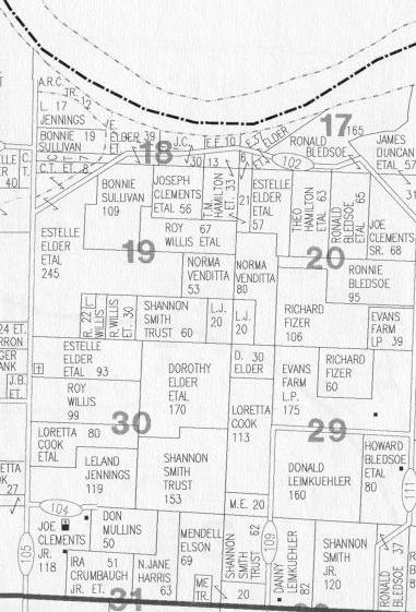
Credit: Saline County, Missouri 1999 Plat Book, p. 9 |
| |
| Hill Farm ~ MAP |
| 1. Abstract No. 5456 |
| Property Description |
| The south part of the northwest quarter of section 8, in township 52 of range 21, containing 87 acres, more or less, and more particularly described as follows, to wit: |
| | Beginning at a point on the west line of said section, 1166 feet south of the northwest section corner of said section 8, thence east 2 degrees 20 minutes north 2625 feet to center line of public road, running north and south, thence south along center line of said public road 1440 feet to the southeast corner of the northwest quarter of said section 8, thence west on quarter section line to the west line of said section 8, thence north on said section line to the point of beginning (the "Eastern Tract"); also |
| The south part of the northeast quarter of the north east quarter of section 7, in township 52, of range 21, containing 7 acres, more or less, and more particularly described as follows: |
| | Beginning at a point on the east line of said section 1166 feet south of the northeast section corner of said section 7, thence west 2 degrees 20 minutes south 1215 feet to the toe of the Missouri River bluff, on the west line of the northeast quarter of the northeast quarter of said section 7, thence south on said line to the southeast corner of the northeast quarter of the northeast quarter of said section 7, thence east on the southline of said quarter section to the east line of said section 7, thence north on said line to the place of beginning; and 9 acres off of the west side of the west half of the southeast quarter of the northeast quarter of said section 7, in township 52, of range 21 (collectively the "Western Tract"). |
| Summary of Title |
| 1836 - | Part of Eastern Tract and other real estate ("east half of the northwest quarter of section 8, in township 52, of range 21, containing 80 acres") conveyed to Williams Mullins by U.S. Government (004). |
| 1897 - | Part of Eastern Tract conveyed to John F. Webb by warranty deed from John and Martha Phillips (046). Excluded from conveyance is a 15 foot strip on east side reserved for an outlet and inlet to northeast quarter of southwest quarter of section 8. |
| 1903 - | Same part of Eastern Tract purchased in 1897 by Webb was conveyed to A.H.W. Sullivan by warranty deed from John F. and Mary C. Webb for $2,400 (047). |
| 1836 - | Remaining part of Eastern Tract and other real estate ("west half of the northwest quarter of section 8, in township 52, of range 21, containing 80 acres") conveyed to Henry Moore by U.S. Government (063).Western Tract and other real estate ("east half of northeast quarter of section 7, in township 52, of range 21, containing 80 acres") conveyed to Singleton Vaughn by U.S. Government (092) |
| 1866 - | William Chase "by George Casebolt his attorney in fact" conveyed a part of the Singleton Vaughn property. |
| 1909 - | Part of Western Tract ("4 acres off the west side of the east half of 13 1/3 acres taken off the west side of the southeast quarter of the northeast quarter of section 7, township 52, range 21") conveyed to A.H.W. Sullivan by warranty deed from Robert and Julia Adams for $100 (121). |
| 1913 - | Part of Western Tract ("all of the six and two thirds acres off the west side of thirteen and one third acres, taken off the west side of the southeast quarter of the north east quarter of section 7, in township 52, range 21") conveyed to A.H.W. Sullivan by warranty deed from Henrietta Oliver for $150 (118). |
| 1902 - | Part of Eastern Tract conveyed to A.H.W. Sullivan by warranty deed from T.H.B. and Margaret Ish for $4,800 (162). This part and the part conveyed by Webb appear to constitute the entire East Tract. This conveyance is dated October 20, 1902 and filed October 31, 1902. |
| 1905 - | Amos H.W. Sullivan and his wife, Mary Sullivan, gave a deed of trust on land, including the Eastern Tract, to secure repayment of a promissory note for $1,000 payable to J.N. Dunlap. The $1,000 note was repaid and the lien released in 1906 (163). |
| 1906 - | Amos H.W. Sullivan gave a deed of trust on the same land, including the Eastern Tract, that earlier secured the Dunlap note. This deed of trust was to secure repayment of a promissory note for $2,500 payable to Mary M. Dunlap. The $2,500 note was repaid and the lien released in 1912 (164). |
| 1908 - | Amos H.W. Sullivan and his new wife, Frances Sullivan, gave a deed of trust on different land, including another part of the Eastern Tract and perhaps part of the Western Tract, to secure repayment of a promissory note for $1,000 payable to B.S. Blackburn. The $1,000 note was repaid and the lien released in 1912 (165). |
| 1935 - | Eastern Tract and Western Tract were still owned by A.H.W. Sullivan at his death and became part of this estate (169). |
| 1936 - | Eastern Tract and Western Tract conveyed to Frank H. Sullivan by warranty deed from other heirs (184-186). |
| 1939 - | 9 acres of the Western Tract conveyed to W.D. Isaacs and Maude Isaacs by Frank H. Sullivan and Ethel I. Sullivan by warranty deed (194-A). |
| 1944 - | Eastern Tract and Western Tract remainder were still owned by Frank H. Sullivan at his death and became part of his estate (200) and were bequeathed to his son, Raymond Sidney Sullivan, subject to a life estate for his wife, Ethel Irene Sullivan. |
| 1966 - | Ethel Sullivan passed away, ending her life estate in the Eastern and Western Tracts. |
| 1987 - | Raymond Sidney Sullivan died and his estate included, among other things, the Eastern and Western Tracts. He bequeathed undivided interests in the Eastern and Western Tracts to his son, William Beaumont Sullivan, and to his daughter, Sidney West Sullivan, subject to a life estate for his wife, Bonnie Mae Sullivan. |
| 2001 - | Bonnie Sullivan passed away, ending her life estate in the Eastern and Western Tracts. |
| William and Sidney Sullivan are the current owners of the Hill Farm comprised of the Eastern Tract and Western Tract. |
| The Hill Farm is largely wooded, hilly acreage, of which approximately 26 acres have been cleared and devoted to farming. Over the years, the tillable land has been farmed for the Sullivan family by a number of farmers. From 1997 until December of 2005 Harold Gene Eddy farmed the Hill Farm followed by the Clements family who assisted in wildlife habitat improvement of the acreage and woods. In December of 2012 Alan Clements and his son Jake took over. |
|
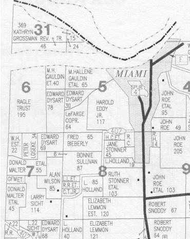
Credit: Saline County, Missouri 1999 Plat Book, p. 12 |
| |